Machine Learning Applications in Tropical Cyclone Analysis Using Satellite Imagery: A Literature Review#
Introduction#
The analysis and prediction of tropical cyclones (TCs) has experienced significant advancement through the integration of machine learning techniques with satellite imagery. This review examines ten seminal papers that represent the evolution and current state-of-the-art in this field, with particular focus on recent developments like TC-GEN and TC-PRIMED that demonstrate the potential of AI-driven approaches in tropical cyclone research.
Paper Reviews#
Paper 1: The Advanced Dvorak Technique: Continued Development of an Objective Scheme to Estimate Tropical Cyclone Intensity Using Geostationary Infrared Satellite Imagery#

Authors: Timothy L. Olander and Christopher S. Velden
Key Highlights:
Development and implementation of a fully automated tropical cyclone intensity estimation system
Systematic evolution from manual to automated technique (ODT->AODT->ADT)
World’s first operational automated system for TC intensity estimation
Real-time implementation across multiple forecast centers
Decade-long validation against aircraft reconnaissance
Integration of objective methods with established meteorological principles
Data Used:
Geostationary satellite infrared imagery from GOES, GMS and Meteosat
Aircraft reconnaissance database (1995-2005):
Methodology:
Automated pattern recognition algorithms:
Spiral centering technique for center location
Ring-fitting method for structure analysis
Automatic scene type classification
Statistical regression for intensity estimation
Latitude-based bias corrections
Integration of original Dvorak technique rules
Key Results:
Elimination of systematic bias present in manual estimates
RMSE of 12.53 hPa vs 9.86 hPa for operational estimates
Optimal performance in mature storm stages
50% accuracy improvement over original ODT algorithm
Strengths:
Complete automation of decades-proven manual technique
Objective and consistent estimates without human intervention
Global applicability across all cyclone basins
24/7 real-time operational capability
Extensive validation against aircraft reconnaissance data
Flexible implementation across multiple computational platforms
Limitations:
Reduced accuracy during formation and dissipation stages
Significant difficulties with weak tropical systems
Limited to infrared imagery use only
Resolution constraints for very small cyclone eyes
Inability to fully replicate human expertise
Dependence on established empirical relationships
Lack of direct wind measurements
Challenges in wind shear conditions
Relevance:
Demonstrates viability of automating complex satellite image analysis
Provides methodological framework for future ML applications
Identifies specific areas for improvement through ML techniques
Demonstrates operational viability of automated systems
Paper 2: Tropical cyclone intensity estimation using a deep convolutional neural network#
Authors: Pradhan, R., Aygun, R. S., Maskey, M., Ramachandran, R., & Cecil, D. J.
Key Highlights:
First implementation of deep CNN for tropical cyclone intensity estimation
Achieves better accuracy than traditional methods (Dvorak and DAVT)
Eliminates need for extensive preprocessing and domain expertise
Provides automated feature extraction from satellite imagery
Generalizable across Atlantic and Pacific regions
Data Used:
98 tropical cyclones (68 Atlantic + 30 Pacific) from 1999-2014
8,138 original IR satellite images
Expanded to 48,828 images through transformations
HURDAT2 data for labeling
Separate recon-only test dataset of 2,646 images
Images taken at 2-hour intervals
Methodology:
Deep CNN architecture:
5 convolutional layers
3 fully connected layers
ReLU activation functions
Local response normalization
Max pooling layers
Dropout (p=0.5) for regularization
Training:
GPU GRID K520 4GB
65 epochs (~8 hours)
Mini-batch system
Learning rate: α=0.001 with γ=0.1 decay
Key Results:
Classification accuracy:
Top-1: 80.66%
Top-2: 95.47%
RMSE: 10.18kt (Atlantic/Pacific)
Recon-only test results:
Top-1: 76.91%
Top-2: 92.55%
RMSE: 11.36kt
Outperforms previous DAVT techniques (14.7kt RMSE)
Strengths:
Automated feature extraction
No requirement for domain expertise
Minimal preprocessing needed
Fast processing time (<1 second per image)
Generalizable across different regions
Lower RMSE than traditional methods
Robust visualization of learned features
Limitations:
Dataset quality issues (grid lines in images)
Limited dataset size
Hardware resource constraints
Hyperparameter optimization challenges
Black patches in some images
Imbalanced category distribution
Relevance:
Demonstrates successful application of deep learning in tropical cyclone analysis
Provides automated, accurate intensity estimation
Reduces human dependency in analysis
Establishes framework for future ML applications
Validates CNN approach for feature extraction
Shows potential for operational implementation
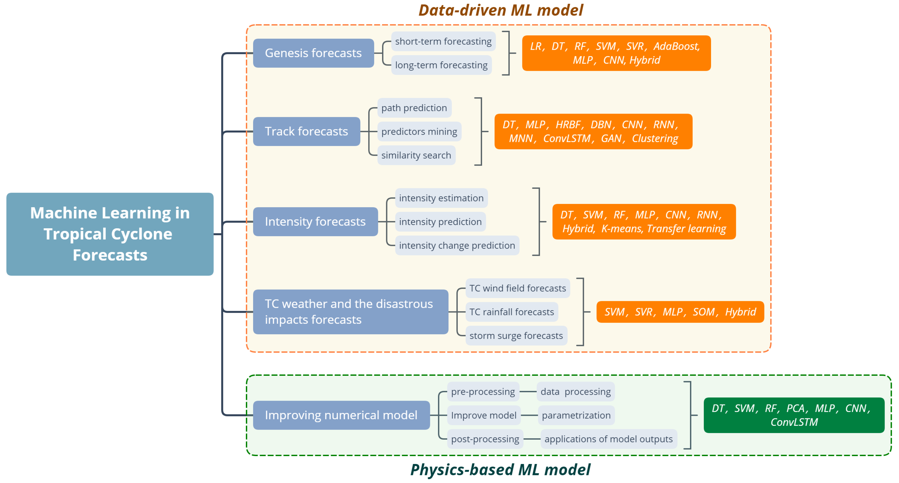
Paper 3: Machine Learning in Tropical Cyclone Forecast Modeling: A Review#
Authors: Chen, R., Zhang, W., & Wang, X.
Key Highlights:
Comprehensive review of ML applications in TC forecasting
Analysis of different ML approaches for genesis/track/intensity prediction
Evaluation of ML integration with numerical weather prediction models
Assessment of opportunities and challenges in TC forecasting using ML
Framework for selecting appropriate ML methods for TC analysis
Data Used:
Satellite imagery (infrared, microwave, multispectral)
Reanalysis datasets (NCEP/NCAR, GFS-FNL)
Best track records from meteorological centers
In-situ observations & aircraft reconnaissance
Numerical model outputs (ECMWF, GFS, UKMET)
Multi-source environmental data (wind, temperature, pressure)
Methodology:
Genesis Forecasting: LR, DT, RF, AdaBoost, SVM, CNN (short-term); SVR, MLP, hybrid networks (seasonal)
Track Prediction: RNN, MLP, GAN, ConvLSTM (neural networks); DT (feature mining); DBN, FMM (similarity)
Intensity Estimation: CNN variants (image analysis); RNN, LSTM (time series); CNN-LSTM (hybrid)
Impact Prediction: SVR/MLP/LSSVM (wind); SVM/hybrid networks (rainfall); MLP/SVR/BPN-ANFIS (surge)
Key Results:
Genesis Detection: >90% accuracy in precursor identification
Track Prediction: Average errors <100km
Intensity Estimation: RMSE ~8kt using CNN
Impact Forecasting: Accurate predictions up to 6 hours
Model Improvement: Enhanced parameterization schemes
Strengths:
Comprehensive coverage of ML applications
Detailed analysis of multiple approaches
Clear evaluation of methods’ effectiveness
Strong focus on practical applications
Successful integration of traditional and ML methods
Limitations:
Limited long-term prediction capability
Model interpretability challenges
Data scarcity for extreme events
Lack of standardized evaluation metrics
Implementation complexity in operational settings
Relevance:
Validates ML effectiveness in TC analysis using satellite imagery
Provides comprehensive methodological frameworks
Identifies promising research directions
Shows practical implementation paths
Establishes foundation for ML-enhanced TC analysis
Demonstrates successful integration of ML with traditional methods
Paper 4: Using Deep Learning to Estimate Tropical Cyclone Intensity from Satellite Passive Microwave Imagery#

Authors: Wimmers, A., Velden, C., & Cossuth, J. H.
Key Highlights:
Introduction of DeepMicroNet CNN model for TC analysis
Novel probabilistic output approach for intensity estimation
First successful deep learning implementation with microwave imagery
Integration of 37 and 85-92 GHz bands
Competitive performance with operational methods
Data Used:
MINT dataset (1987-2012)
Multiple satellite sources (DMSP SSM/I, SSMIS, TRMM TMI, Aqua AMSR-E)
400km x 400km images at 5km resolution
Filtered TC data over water
65% scan coverage requirement
Methodology:
CNN architecture based on AlexNet design
15 convolutional layers + 2 fully connected layers
Cross-entropy loss function training
Data augmentation techniques
Three model versions (37 GHz, 89 GHz, combined)
Key Results:
RMSE of 14.3 kt vs global best track
RMSE of 10.6 kt vs aircraft reconnaissance
89 GHz band proved more influential
6-hour forecasting capability
RMSE of 9.6 kt with high-resolution data
Strengths:
Robust to partial scan coverage
Resistant to center-fixing errors
Provides uncertainty estimates
No manual calibration required
Global applicability
Operational-level performance
Limitations:
Limited Category 5 hurricane performance
Training data constraints
Model interpretability challenges
Limited temporal resolution
Performance degradation beyond 6 hours
Satellite coverage gaps
Relevance:
Demonstrates deep learning viability for TC analysis
Provides operational system foundation
Enables automated TC intensity estimation
Shows potential for method integration
Advances satellite-based TC analysis
Paper 5: Deep Learning for Hurricane Track Forecasting from Aligned Spatio-temporal Climate Datasets#
Authors: Giffard-Roisin, S., Yang, M., Charpiat, G., Kégl, B., & Monteleoni, C.
Key Highlights:
Implementation of a novel moving frame of reference CNN model
Development of a fusion network architecture combining wind fields, pressure data, and trajectory information
First deep learning approach for 24h hurricane track forecasting using multiple atmospheric levels
Integration of data from both hemispheres in a single model
Data Used:
IBTrACS database: >3000 storm tracks since 1979
ERA-interim reanalysis data:
Wind fields (u,v)
Geopotential height
3 pressure levels (700/500/225 hPa)
25x25 degree grid centered on storm locations
6-hourly temporal resolution
Methodology:
Three-stream neural network architecture:
Wind CNN: Processing wind field data
Pressure CNN: Processing pressure data
Past tracks + meta NN: Processing trajectory and metadata
Fusion network combining all three streams
Moving reference frame approach
Training split: 60% train / 20% validation / 20% test
Key Results:
Mean 24h forecast errors:
Fusion network: 128.9 km
Wind CNN: 141.1 km
Pressure CNN: 161.3 km
Past tracks NN: 184.8 km
Outperformed statistical BCD5 model
Competitive with OFCL until 2010
Strengths:
Effective data fusion approach
Global applicability (both hemispheres)
Moving reference frame innovation
Complementary to existing forecasting methods
Limitations:
Performance not superior to post-2010 OFCL forecasts
Limited to 24-hour forecasts
Requires substantial computational resources
Dependent on quality of reanalysis data
Relevance:
Demonstrates viability of deep learning for hurricane forecasting
Establishes framework for multi-source data fusion
Provides complementary approach to current forecasting methods
Potential for integration with existing prediction systems
Paper 6: Tropical Cyclone Intensity Estimation Using Multi-Dimensional Convolutional Neural Networks from Geostationary Satellite Data#
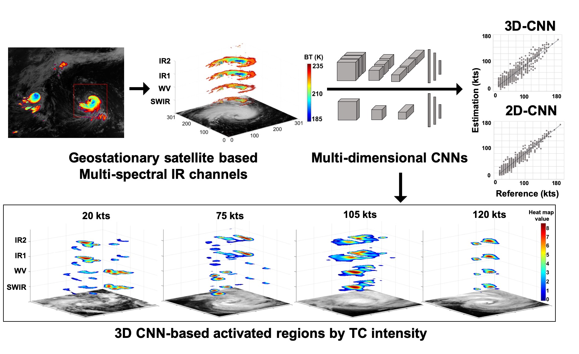
Authors: Lee, J., Im, J., Cha, D. H., Park, H., & Sim, S.
Key Highlights:
First implementation of multi-spectral analysis for TC intensity estimation using CNNs
Development of both 2D and 3D CNN architectures for TC analysis
Introduction of heat maps for model interpretation
Improvement of ~35% over existing single-channel methods
Data Used:
COMS MI satellite data (2011-2016)
4 infrared channels: SWIR (3.7μm), WV (6.7μm), IR1 (10.8μm), IR2 (12.0μm)
JTWC best track data for validation
Additional validation data from 2017 TCs
Methodology:
Image preprocessing: 301x301 pixel patches resized to 101x101
Data balancing through subsampling and oversampling
2D-CNN and 3D-CNN architectures implementation
Multiple evaluation metrics (MAE, RMSE, rRMSE, ME, MPE, NSE)
Key Results:
2D-CNN model: RMSE = 8.32 kts
3D-CNN model: RMSE = 11.34 kts
35% improvement over previous single-channel models
Successful validation on 2017 cases
Strengths:
Multi-spectral analysis capability
Automated and objective estimation
Model interpretability through heat maps
Consistent with Dvorak technique patterns
Limitations:
High computational demands for 3D-CNN
Limited hyper-parameter optimization
Difficulty in fully understanding model decisions
Computational resource constraints
Relevance:
Provides automated TC intensity estimation
Improves accuracy over traditional methods
Offers real-time analysis potential
Contributes to operational meteorology
Paper 7: Physics-Augmented Deep Learning to Improve Tropical Cyclone Intensity and Size Estimation from Satellite Imagery#

Authors: Zhuo, J. Y., & Tan, Z. M.
Key Highlights:
Development of DeepTCNet: A physics-augmented deep learning framework for TC analysis
Novel integration of physical knowledge into CNN architecture
First comprehensive DL approach for simultaneous TC intensity and wind radii estimation
Significant improvement over traditional methods (ADT and MTCSWA)
Data Used:
IBTrACS database (2005-2019) for intensity and wind radii
HURSAT-B1 IR imagery (up to 2016)
GridSat-B1 archive (post-2016)
TC Vitals Database for auxiliary storm information
Training: 2005-2015
Validation: 2016, 2018
Testing: 2017, 2019
Methodology:
Base Architecture: Modified VGGNet with 13 layers
Single-Task Learning (STL) for intensity estimation
Multi-Task Learning (MTL) for wind radii estimation
Physics augmentation through:
TC fullness integration
Auxiliary physical information
Sequential IR imagery analysis
Key Results:
39% improvement over ADT in intensity estimation
32% improvement over MTCSWA in wind radii estimation
Comparable performance to SATCON
Relative error ~8% for all TC categories
Successful validation with aircraft reconnaissance data
Strengths:
Real-time operational capability
Interpretable through saliency maps and LRP
Effective physics integration
Simultaneous multi-parameter estimation
Basin-independent application potential
Limitations:
Underestimation of very intense TCs
Limited training data for extreme events
Dependent on IR imagery resolution
Requires quality-controlled historical data
Performance varies with TC structure complexity
Relevance:
Advances operational TC monitoring capabilities
Improves satellite data utilization efficiency
Demonstrates successful physics-ML integration
Provides foundation for future TC analysis systems
Supports real-time decision making
Paper 8: DMANet_KF: Tropical Cyclone Intensity Estimation Based on Deep Learning and Kalman Filter From Multispectral Infrared Images#

Authors: Jiang, W., Hu, G., Wu, T., Liu, L., Kim, B., Xiao, Y., & Duan, Z.
Key Highlights:
Introduction of DMANet (Deep Multisource Attention Network)
Novel Message-Passing Enhancement Module (MPEM)
Local Global Attention Module (LGAM)
First-time application of Kalman Filter for TC intensity correction
Data Used:
Japanese Meteorological Satellites data (MTSAT-1R, MTSAT-2, HIMAWARI-8)
Period: 2007-2021
343 Tropical Cyclones
Four infrared channels (IR1: 10.3-11.3 μm, IR2: 11.5-12.5 μm, IR3: 6.5-7.0 μm, IR4: 3.5-4.0 μm)
Methodology:
DMANet architecture with MPEM and LGAM modules
MPEM based on conditional random fields (CRFs)
LGAM with local and global attention mechanisms
Kalman Filter for time series correction
Data preprocessing including image transformation and resampling
Key Results:
RMSE reduction from 9.79 to 7.82 knots with Kalman Filter
9.07% improvement over existing methods
Best performance in violent category TCs
Outperforms general models (AlexNet, VGG-16, ResNet-50)
Strengths:
Effective multispectral data integration
Automatic feature extraction
Real-time processing capability
Robust performance across TC categories
Innovative time series correction
Limitations:
Dataset imbalance issues
Limited to Northwest Pacific Basin
Dependent on clear satellite imagery
Computational resource requirements
Regional specificity
Relevance:
Advances in TC intensity estimation
Improved disaster preparedness
Automated analysis system
Enhanced accuracy in violent TC category
Integration of multiple data sources
Comparison of Approaches#
Methodology/Technique |
Key Strengths |
Key Limitations |
|---|---|---|
Traditional Automated Methods (ADT) |
- Complete automation of proven manual techniques |
- Reduced accuracy during formation/dissipation |
Deep CNN |
- Automated feature extraction |
- Dataset quality issues |
Multi-spectral CNN |
- Multi-channel analysis capability |
- High computational demands |
Physics-Augmented Deep Learning |
- Real-time operational capability |
- Underestimation of intense TCs |
Deep Multisource Attention Network |
- Effective multispectral integration |
- Dataset imbalance issues |
Challenges and Future Directions#
Technical Challenges#
High computational resource requirements
Model interpretability issues
Integration of physical constraints with ML models
Real-time processing limitations
Future Research Directions#
Development of hybrid models combining physical and ML approaches
Improved techniques for handling data imbalance
Enhanced model interpretability methods
Cross-basin generalization techniques
Integration of multiple data sources
Advanced time series analysis methods
Real-time processing optimization
Conclusion#
The review of these papers reveals significant progress in applying machine learning to tropical cyclone analysis, particularly in the areas of intensity estimation and track prediction. Key developments include:
Evolution from traditional automated methods to sophisticated deep learning approaches
Successful integration of physical understanding with ML techniques
Improved accuracy through multi-spectral analysis
Development of real-time operational capabilities
The field is moving toward more sophisticated hybrid approaches that combine the strengths of traditional methods with modern ML techniques. The most promising directions appear to be in physics-augmented deep learning and multi-source data integration approaches.
Questions About Methodologies and ML Approaches#
Data Preparation and Quality#
How are satellite imagery inconsistencies handled across different sources?
What preprocessing steps are critical for model performance?
How is data augmentation implemented effectively?
Model Architecture#
What factors determine the optimal network depth and complexity?
How are physical constraints incorporated into neural network architectures?
What attention mechanisms are most effective for TC analysis?
Training Process#
How are hyperparameters optimized across different approaches?
What strategies address class imbalance issues?
How is overfitting prevented with limited data?
Evaluation Metrics#
What metrics best capture real-world operational requirements?
How is model performance compared across different basins?
What validation approaches ensure operational reliability?
Practical Implementation#
How are models deployed in operational settings?
What computational resources are required for real-time analysis?
How is model maintenance and updating handled?
Reproducibility#
What details are needed to reproduce results?
How are model weights and architectures shared?
What benchmarking procedures ensure consistent evaluation?
References#
Olander, T. L., & Velden, C. S. (2007). The advanced Dvorak technique: Continued development of an objective scheme to estimate tropical cyclone intensity using satellite infrared imagery. Weather and Forecasting, 22(2), 287-298. https://doi.org/10.1175/WAF975.1
Pradhan, R., Aygun, R. S., Maskey, M., Ramachandran, R., & Cecil, D. J. (2017). Tropical cyclone intensity estimation using a deep convolutional neural network. IEEE Transactions on Image Processing, 27(2), 692-702. https://doi.org/10.1109/TIP.2017.2766358
Chen, R., Zhang, W., & Wang, X. (2020). Machine learning in tropical cyclone forecast modeling: A review. Atmosphere, 10(9), 496. https://doi.org/10.3390/atmos11070676
Wimmers, A., Velden, C., & Cossuth, J. H. (2019). Using deep learning to estimate tropical cyclone intensity from satellite passive microwave imagery. Monthly Weather Review, 147(6), 2261-2282. https://doi.org/10.1175/MWR-D-18-0391.1
Giffard-Roisin, S., Yang, M., Charpiat, G., Kégl, B., & Monteleoni, C. (2018, December). Deep learning for hurricane track forecasting from aligned spatio-temporal climate datasets. In Modeling and decision-making in the spatiotemporal domain NIPS workhop. https://hal.science/hal-01905408v1
Lee, J., Im, J., Cha, D. H., Park, H., & Sim, S. (2019). Tropical cyclone intensity estimation using multi-dimensional convolutional neural networks from geostationary satellite data. Remote Sensing, 12(1), 108. https://doi.org/10.3390/rs12010108
Zhuo, J. Y., & Tan, Z. M. (2021). Physics-augmented deep learning to improve tropical cyclone intensity and size estimation from satellite imagery. Monthly Weather Review, 149(7), 2097-2113. https://doi.org/10.1175/MWR-D-20-0333.1
Jiang, W., Hu, G., Wu, T., Liu, L., Kim, B., Xiao, Y., & Duan, Z. (2023). DMANet_KF: Tropical cyclone intensity estimation based on deep learning and Kalman filter from multispectral infrared images. IEEE Journal of Selected Topics in Applied Earth Observations and Remote Sensing, 16, 4469-4483. https://doi.org/10.1109/JSTARS.2023.3273232